FlyThrough Race-Map – Next Generation Race Maps
November 14, 2017
The announcement was made by our Founder & CEO, Eitan Hefetz, during the Innovators’ Pitch session at the European Running Business Conference in Frankfurt.
“We have designed FlyThrough Race-Map to offer races a next-generation race map they can place on the race website before the race, letting participants explore the course prior to the race,” Hefetz explained. “We believe this new 3D Interactive solution will gradually replace the traditional 2D race maps commonly used by races today”.
FlyThrough Race-Map offers the option to setup different point-types (photography points, water points etc.), highlight landmark points along the course, switch between different routes as well as highlight the main sponsor through an interactive user interface.
“FlyThrough Race-Map is another solution we are releasing as part of our constant effort to revolutionize race participants’ experience-sharing through digital solutions, while boosting marketing value for race sponsors,” said Hefetz.
The release of FlyThrough Race-Map comes on the back of the recent release of after-race experience platform RunPage, further strengthening Pic2Go’s rich digital experience sharing solutions that include automated race photo sharing, Performance Photos and Performance Videos.
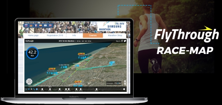
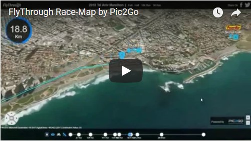
We were happy to announce October 28th the addition of 3D Interactive FlyThrough Race-Map to our Pic2Go platform - offering races with a next generation race-maps solution!
The announcement was made by our Founder & CEO, Eitan Hefetz, during the Innovators’ Pitch session at the European Running Business Conference in Frankfurt.
“We have designed FlyThrough Race-Map to offer races a next-generation race map they can place on the race website before the race, letting participants explore the course prior to the race,” Hefetz explained. “We believe this new 3D Interactive solution will gradually replace the traditional 2D race maps commonly used by races today”.
FlyThrough Race-Map offers the option to setup different point-types (photography points, water points etc.), highlight landmark points along the course, switch between different routes as well as highlight the main sponsor through an interactive user interface.
“FlyThrough Race-Map is another solution we are releasing as part of our constant effort to revolutionize race participants’ experience-sharing through digital solutions, while boosting marketing value for race sponsors,” said Hefetz.
The release of FlyThrough Race-Map comes on the back of the recent release of after-race experience platform RunPage, further strengthening Pic2Go’s rich digital experience sharing solutions that include automated race photo sharing, Performance Photos and Performance Videos.
- Tweet
 6 years ago
 2638 Views